Sunday, February 5, 2012

In the desert

 If I climb to the top of the rocky hill behind the composting toilet, I can get 3 bars of cell phone service, so I I may do a blog post before the week us up after all.

Right now I am sitting at a desert campground in the Picacho wilderness area, after having just completed a day of hiking with the Sierra club. There are 12 of us in all, a great group. Today we hiked beautiful slot canyons through this rocky area. Sunshine and 72, not a cloud in sight. Saw some wild burros, lots of ocotillo but only one bloom, some desert lavender just starting to bloom, a defunct desert turtle shell, and lots of wonderful scenery. It's a 25 mile drive over 25 mph gravel roads to get here, passing through pinnacle of red, green, and gray. No trees to speak of, except possibly right down by the river....the Colorado runs right along the edge of the campground.

This is an amazing campground for being so far out in the wilderness. Running water and free hot showers. There's hardly anyone here... there are at least 50 campsites and maybe 8 are occupied, this during what is surely high season here. 

It's chilly at night, at least down into the 40's. We've got almost a full moon which is a mixed blessing.... you don't need a flashlight, but the stars aren't as numerous as they would otherwise be. 

Pictures later.....

Saturday, February 4, 2012

Pictures from Carizzo Plain National Monument

Euchie enjoying the birds at Carrizo Plain National Monument


This is the road where I had to clear tumbleweed roadblocks


Soda Lake, totally dry right now.


A beautiful view leaving the monument


This is probably my last post until next weekend. I'll be in the wilderness with the Sierra Club until the 11th, then driving to Las Vegas on the 12th to start bike tour on the 13th. Stay tuned! 

Friday, February 3, 2012

Yuma At last

 Yesterday, after a nice slow morning enjoying coffee and blogging,  I visited Carrizo Plain National Monument. Never heard of this one either, have you? It's certainly not on the way to anywhere, very poorly signed, and down 30-some miles of rough road that the map says is a dead end. After coming over a small mountain range and lots of those low, brown hills, it's startling to come upon this vast, flat, treeless plain. At 2200 feet it's cool...the woman at the visitor center says it was down in the single digits at night recently.... and one of the sunniest places in the state.  Like Pinnacles, it sits right on the San Andreas fault. I wish I had time to spend a day or two there. Just driving through, it seems like there's no "there" there, but it's so, so quiet, and I can only imagine what the stars would be like. They've had no rain (well, .28") so far this year, so Soda Lake, which has no outlet, is dry and white with salt deposits. And yet there are birds everywhere, and squirrels, and kangaroo rats, and coyotes.... what do they drink???

I took a drive on a side road in the park, and had to clear several tumbleweed roadblocks.

Driving on past where my roadmap said the road dead-ended (but the park attendant assured me it didn't), I eventually got back to a highway which took me over the Temblor Range, and what a shock at the top.... A view of flat forever. Coasting down a long 7% grade brought me into a long, straight stretch of irrigated desert filled with mile after mile of orange groves.

Then on the freeway towards Los Angeles, up over that beautiful 4000' mountain pass and down into the beginnings of the metropolis. I decided I wasn't up for navigating the city during rush hour, so opted to stay for the night in Santa Clarita, home of Six Flags over California, aka, I think, Magic Mountain, since my hotel was on Magic Mountain Parkway, in sight of rollercoasters.

Something I meant to write about yesterday after my Pinnacles adventure. As I was climbing up those footholds cut in the rocks, it came to me that no one in the world knew where I was, and I had only seen maybe a half-dozen other hikers all day, and I definitely did NOT have the 10 essentials with me. Probably not the smartest thing. But I was careful and I survived.... to do a drive on backroads in the desert the next day, thinking much the same thing. 

Right now I'm just east of San Diego having lunch. Another 2.5 hours to Yuma, where hopefully I'll have plenty of time to do washing and a little shopping before driving another hour or so to meet up with my Sierra Club trip. Also hoping to find a bike shop...Ipad says there's one near my hotel....where I can leave my bike to be cleaned up and tuned a bit. It's pretty sad looking after driving those dusty desert roads yesterday, needs a tune-up anyway, and I'm hoping I can leave it at a bike shop so I don't have to leave it on the back of my car, which will be parked somewhere out in the desert for the 4 days we'll be canoeing.

Later: Yuma at last! In my shorts, having a beer. Dropped my bike off, the laundry's in the wash, heading to Supercuts, just down the road, when it's done.

What a drive! Sea level at San Diego, then over three 4000+ foot passes, then back to sea level in the desert. This has got to be one of the most scenic freeway drives I've ever taken. The mountains east of San Diego are strewn, covered, with amazing house-sized boulders. No trees, just boulders and desert, even at 4000 feet. Then down below, after miles of scrub-desert, there are miles of beautiful sand dunes (the Algodones dunes, I think). When I biked through near  here in 2005, those dunes were covered with beautiful purple flowers, but that was in March; no sign of anything but sand this time. And dune buggies.

It's been a great trip so far, but I'm happy to not be driving much for the next couple of weeks. Just to the meeting point with Sierra Club tomorrow, and then next weekend from here to Las Vegas to meet up with WomanTours for the bike trip through Death Valley.

Too tired to mess with uploading pictures tonight....


Thursday, February 2, 2012

Pinnacles

 Starbucks right next to my hotel this morning... now that's what I'm talkin' about!

I got to Paso Robles just after dark last night, very tired. Asked the nice woman at the hotel where to eat, and she gave me this map that showed Red Brick Pizza very close, she said even within walking distance. Having walked quite a bit already (see below) I thought I'd drive there anyway. Couldn't really tell whether the restaurant was to the right or left, so I started out right...1/2 mile, nothing. Turned around, went almost a mile, nothing (now I'm tired and hungry and it's dark, I'm swearing). Back to the hotel, dammit, I'll just go to the crappy Denny's clone attached to the hotel. Sustenance, anyway. As I'm leaving the restaurant I notice...right there, almost ATTACHED to the hotel, are about 6 eateries, including the one I'd been looking for, and Starbucks. Like I say, I was tired, and it was dark.

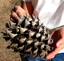
Anyway, that walk... 8 strenuous miles and 1600 feet of elevation gain in 5 hours at Pinnacles National Monument. Have you ever heard of this place? Neither had I. Well worth a visit. After a 15 mile winding and scenic drive through wineries and those beautiful dry California hills, big rocky..well...pinnacles. Rock spires, ramparts, crags, massive monoliths, sheer-walled canyons. This is part of an ancient volcano, lying right atop the San Andreas fault. Blue oak and gray pine, 2 new trees I learned today. Gray pine has perhaps the most impressive cones I've ever seen  and blue oak has these odd, long and narrow acorns.

Euchie enjoying the balcony of the nice B&B in Carmel

 About 3/4 of the way through this hike I came to the High Peaks area, with a sign saying "steep and narrow". Wow!


Steep and narrow!


Tuesday, January 31, 2012

Monterey and Carmel

 I have fallen more deeply in love with my Ipad today. A few days ago, I downloaded a GPS app, for, I think, $1.99. Today it talked me through all the turns from Calistoga to the Monterey Bay Aquarium. (more on that in a bit). Afterwards I sat in my car and used my cellular internet connection to go to hotels.com and find a nice little B&B in Carmel, for less than $60. Trusty Ipad guided me on, and I'm now there, sipping the remainders of yesterday's wine.

Also, the ipad battery has lasted all day, and still says it's got 24% left. And the car charger that I already had for my ipOd seems to work fine for it, too.

The aquarium lived up to expectations. Most enjoyable to me were the displays of sea jellies, including an opportunity to see baby ones through a microscope; and a large and amazing display of sea horses... from babies to adults to sea dragons (yes, there is such a thing) which surely do not look like they belong in this world at all. I tried to find someone who could tell me what the jelly marbles in Oregon might have been, but no luck. 

I was hoping to drive down to Ventura tomorrow and catch a boat out for a day in Channel Islands National Park on Thursday. However, the only boat on Thursday goes to Anacapa Island, and as near as I can tell, once you get there, there's a 1.5 mile nature trail, and that's it. Would rather go to Santa ...,  but no boat until Friday, and I need to be in  or near Yuma on Friday night, another fairly long drive, so I guess it will have to wait until another time.

I just got interested in the Channel Islands... truth be told, just learned of their existence... after reading T. C. Boyles' "When the Killing's Done" a few weeks ago. Good book.

So now I'm dithering about what to do for the next 3 days. May stick around here tomorrow and go biking. Seems like there are a lot of nice trails around here.

Redwoods to Vineyards, Boots to Sandals

 Enjoying breakfast in bed at a fancy hotel. My only choice, as I am in the upscale tourist town of Calistoga. Yes, its where Calistoga spring water is from, and theres a note in my room saying I can fill my carafe from the spring downstairs in the lobby.

What a drive yesterday! A ways south of Eureka, I turned off on Highway 1, certainly the windingest, hilliest road I have every been on. Marvelous, as long as you're not in a hurry. The speed limit might be 55, but I don't think I ever got to that on this road... more like 35 most of the way. Even with hundreds of hairpin curves, blind corners, no shoulder, un-guardrailed drop-offs, I occasionally saw signs proclaiming it as a bike route. I am a pretty brave biker, but really, you'd have to be suicidal! True, there wasn't a lot of traffic, but there's got to be a lot more in the summer, and really, I think they'd just have to close it to cars (Ooooh, wouldn't that be wonderful!) for me to ride it.

Eventually I made it to Fort Bragg, where I found a nice little natural-foods place for lunch. True to the California stereotype, seems like every little town has one of these.  Here, I traded my hiking boots for sandals, and my sweater for a t-shirt! Yippee!

Stopping for a latte on the way out of town, I asked the barista if the road going south was as curvy as the one coming in. She said "There's no way out of Fort Bragg without at hour of winding roads"... you would've had to hear her tone of voice....sounded like she'd been there a bit too long....

But she was right. I decided to head inland toward the wine country, but the road was much the same. Gradually changing from redwood forest to hilly chapparal, and then vineyards, vineyards, vineyards, vineyards, and vineyards. Countless tasting rooms, one of which I finally stopped at mainly to use the restroom, but I did buy a bottle of wine from them. This was in and area that I think is called the Anderson valley, which eventually lead to the Napa valley, which as I'm sure you can imagine is even more vineyard-filled.

Not long after I left Fort Bragg I realized I'd forgotten to get gas, so pulled into a station in a tiny tiny town. Old, old pumps, the kind with mechanical odometer-type numbers. $4.55 a gallon! Yipes! I just bought enough to get me back to civilization... 

Calistoga: Art galleries (mediocre, tourist-trade), restaurants ($$$), B&B's ($$$), restaurants ($$$), wine shops. I thought I'd stumbled upon a reasonably priced restaurant until I asked if anything came with that $11 order of crab cakes, and was told that it's a tapas bar and the chef recommended at least two orders for a dinner. Don't get me wrong, this is a pretty town and worth a visit, just be forewarned that it is pricey. And this is the off-season.

A couple of nice ocean views near Mendocino. Lots of cool seastacks.


Sunday, January 29, 2012

California!

Euchie enjoying his ocean view

Euchie enjoying the ocean view

 This morning's latte was in Gold Bar, OR. I didn't make it very far yesterday because I got enchanted by the Cape Perpetua area and thus spent several hours hiking there. In the sunshine. In shirtsleeves: eat your heart out! Down to a basin called Devil's Churn, and the Horn Spout, neither of which were very impressive because it was low tide, but still of course very beautiful. Then a steep hike up to the top of the cape, billed as the best view on the Oregon Coast. I can't argue.

View from Cape Perpetua

Ocean view lodgings again last night, where I slept like a baby. So far I am sleeping much better on this trip than I do at home... perhaps because there's not a cat meowing for me to get up at 4am?

My motto for this (and all other) trips!

Now Euchie and I are in California!  Stopped to hike in the Redwoods outside of Crescent City for a while, then drove on to Eureka, where I'm spending the night. My first time seeing redwoods... it's easy to get jaded. After you see a few of them, they don't look that big anymore. I had to keep reminding myself that most of them are at least 15' in diameter. And 200-300' tall. 

Staying in Eureka tonight. Weather has turned to rain, so I think I will push southward and inland tomorrow...

marvelous sand patterns at Yachats

Note Euchie under the sign!

Trying to get a picture of how big the redwoods are. Very difficult~!

Many of these jello-marbles on the beach at Yachats. Some sort of beach creature Wonder what they are?