Thursday, February 23, 2012

Socks, boots, and a sweater

Back to socks, boots, and a sweater, and it rained during the night: I'm almost home! Just having my morning coffee in Roseburg, OR, before starting one more long day's drive.

I about panicked yesterday in Medford, when my map app said the nearest Starbucks was a 7 hoour drive away. But the kindly gas station attendent (I'm in Oregon, where they still pump your gas for you) directed me to one just across the street in the mall. And this morning it's found me three in Roseburg, so who knows why it couldn't find them yesterday.

The drive through the Siskiyous was lovely, one area of rain and fog but no snow, and it's such a beautiful drive. So nice to be back among green, forested hills again.

I'm impressed that I've used less than half of my allotted 1GB of network traffic ($20 for up to 1GB in 30 days) on this trip, and I've used it nearly every day. Also bought an ipad car charger at Radio Shack that works.

Ok, Homeward!


Tuesday, February 21, 2012

Out of the desert

Well, I wrote a nice offline blog entry yesterday, but it has disappeared. Don't quite understand this. But will try to reproduce.

I'm now in Davis, CA, having spent the night with a friend. Will stay here again tonight and then put pedal to the metal for home tomorrow.

The past two days have been long slogs of driving. First a whole day again throught the Mojave. Then out of the desert and into the vast central California orchard and vineyard area. I have to say that route 99 from Bakersfield to Sacramento is perhaps the ugliest drive I've ever taken.... imagine 300 miles of Aurora avenue, improved only by the fact that it's freeway so you can get through it a bit faster. Lots of traffic, about half of it trucks. Not a drive I would willingly do again.

Highlights of the drive:

1. A vast windfarm in Tehachapi pass, just outside of the town of Mojave. Thousands and thousands of wind turbins... Google says 5000 but it looked like more to me. I have mixed feelings about this: power for close to half a million homes, but it totally changes the landscape... It's the dominate feature for miles and miles.

2. Some nutcake paid for a 50-foot professionally made banner: "HIGH SPEED RAIL ADVOCATES: EAT S**T AND DIE!" There is a project underway for high speed rail from Sacramento through SF, Fresno, LA, all the way to San Diego. Sounds great to me...

3. At an offramp in Modesto, there was a guy with a "will work for food, anything helps" sign. But he didn't really look like the typical homeless guy. Then I noticed at the bottom of the sign it said "walking from Mexico to Canada". Only got a chance to exchange a few words with him, but he said he'd started a month ago. Who knows if it's true, but I gave him a buck.

4. Trees again, at last.

My latest favorite thing about my ipad: I found out I can just type "starbucks" into the map and it immediately shows me where to get my morning latte!

Saturday, February 18, 2012

Death Valley to Las Vegas

 Friday night in Las Vegas... wow. President's day weekend, too.  I spent a couple of hours last night walking around the strip, gawking. Turned $5 into $40 at the slot machines but then of course gave it all back plus another $30. Saw Darth Vader, Captain Jack, a guy inexplicably on stilts (or else he really was 8 feet tall?), many young women in impossibly short, tight dresses. And lots and lots of people of every age, size, shape, and description. Parents with young children. An older woman in a long wool coat and babushka scarf. Fat tourists in t-shirts. (my peeps!) A cadre of young men in dark suits and dark glasses. 10:30pm at Wallgreens, there were 8 cashiers and line of people still.... probably everyone needs aspirin, like me. I am taking a nice slow Saturday morning here in my room, saving energy to go back out tonight and gawk some more before taking off northward tomorrow morning.

Lowest point was actually -280 feet, but no sign there.

Yesterday started with an 18 mile, 3200 foot climb, by bike, up out of Death Valley. Followed by an excellent 12 mile downhill to meet the WomanTours van for a picnic lunch in Amargosa: This place could well have been where Baghdad Cafe  was filmed.  Then 3 hours in the van back to Las Vegas, dropping people at the airport and various hotels.

Death Valley averages only about 2 inches of rain per year, so I guess I should feel lucky to have seen it. Weather was cloudy and threatening rain for our first 3 days there; I can't say I ever really got wet, but I rode in long pants and long sleeves. On our 4th day, though, the sun came out in full force and it was just lovely, 70, clear blue sky, and a 20mph tailwind... well, it was a tailwind for the first half of the day anyway. The highlight of the trip for me was riding a 12 mile loop called Artist's Drive. Incredible colors... a fairlyland of mint green, pink, forest green, peach, gold, rust. 15% grades and a 20mph headwind just made it more memorable.

Just one of the marvelous geological formations in Death Valley

Dunes in Death Valley

I do think I'd like to go back to Death Valley, but more to hike than bike. There are so many little side canyons to explore, dunes, plantlife, incredibly varied geological formations... one mountain will be peach colored, the one right next to it jet black,  the next one horizontal stripes of rust, pink, and brown, and the next one with the same stripes but running diagonally. Plains of sand, plains of gravel, plains of big black rocks. Sand dunes, marble slot canyons. And all of this surrounded by 10,000 foot snowcovered peaks.

Badwater salt flats, death valley


Monday, February 13, 2012

Picacho Peak, Canoeing, and Death Valley at last

 Here I am in Death Valley, at Stovepipe Wells Village. We were shuttled from Las Vegas to Rhyolite this morning. After lunch we got on our bikes at last, for a fairly easy 32 mile ride to here. Up less than a thousand feet to get over a 4200 foot pass, where it was SNOWING -- not what I expected here!---- and then down down down, back down to sea level and below. 13 miles of coasting downhill at a good 30+ mph, which would have been a bit more comfortable without the sleet, but that was gone by the time we got down a few thousand feet. 

Yesterday... hard to believe it was only yesterday:  6 hours of driving through the Mohave desert from Yuma to Las Vegas, me and hundreds of RV's. Tiring and really not all that scenic, vast ugly RV encampments of snowbirds interspersed with vast areas of nothing. Possibly I am just getting tired of desert. I do admit to a mild craving for some lush, moist, greenery, and ocean. And just as I was entering LV, the batteries ran out on Ipad and my trusty GPS app would not guide me to the hotel. I managed to remember the street name and got there without much ado. Note to self: Need a new car charger for Ipad.

Here are some pictures from my week of hiking and canoeing with the Sierra Club. I think I will let them speak for themselves:

The view from one our campsites

Colorado River colors


An old miners cabin


Floating down the river

Many winding narrow channels through the reeds along the river.

Euchie enjoying camping at Picacho State Recreation Area

There were whole mountains and canyons of this malachite colored rock around Picacho Peak.

A little rest along the trail...

Slot canyons around Picacho Peak


Sunday, February 5, 2012

In the desert

 If I climb to the top of the rocky hill behind the composting toilet, I can get 3 bars of cell phone service, so I I may do a blog post before the week us up after all.

Right now I am sitting at a desert campground in the Picacho wilderness area, after having just completed a day of hiking with the Sierra club. There are 12 of us in all, a great group. Today we hiked beautiful slot canyons through this rocky area. Sunshine and 72, not a cloud in sight. Saw some wild burros, lots of ocotillo but only one bloom, some desert lavender just starting to bloom, a defunct desert turtle shell, and lots of wonderful scenery. It's a 25 mile drive over 25 mph gravel roads to get here, passing through pinnacle of red, green, and gray. No trees to speak of, except possibly right down by the river....the Colorado runs right along the edge of the campground.

This is an amazing campground for being so far out in the wilderness. Running water and free hot showers. There's hardly anyone here... there are at least 50 campsites and maybe 8 are occupied, this during what is surely high season here. 

It's chilly at night, at least down into the 40's. We've got almost a full moon which is a mixed blessing.... you don't need a flashlight, but the stars aren't as numerous as they would otherwise be. 

Pictures later.....

Saturday, February 4, 2012

Pictures from Carizzo Plain National Monument

Euchie enjoying the birds at Carrizo Plain National Monument


This is the road where I had to clear tumbleweed roadblocks


Soda Lake, totally dry right now.


A beautiful view leaving the monument


This is probably my last post until next weekend. I'll be in the wilderness with the Sierra Club until the 11th, then driving to Las Vegas on the 12th to start bike tour on the 13th. Stay tuned! 

Friday, February 3, 2012

Yuma At last

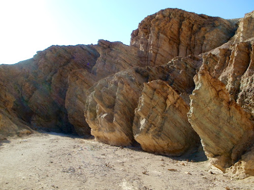
 Yesterday, after a nice slow morning enjoying coffee and blogging,  I visited Carrizo Plain National Monument. Never heard of this one either, have you? It's certainly not on the way to anywhere, very poorly signed, and down 30-some miles of rough road that the map says is a dead end. After coming over a small mountain range and lots of those low, brown hills, it's startling to come upon this vast, flat, treeless plain. At 2200 feet it's cool...the woman at the visitor center says it was down in the single digits at night recently.... and one of the sunniest places in the state.  Like Pinnacles, it sits right on the San Andreas fault. I wish I had time to spend a day or two there. Just driving through, it seems like there's no "there" there, but it's so, so quiet, and I can only imagine what the stars would be like. They've had no rain (well, .28") so far this year, so Soda Lake, which has no outlet, is dry and white with salt deposits. And yet there are birds everywhere, and squirrels, and kangaroo rats, and coyotes.... what do they drink???

I took a drive on a side road in the park, and had to clear several tumbleweed roadblocks.

Driving on past where my roadmap said the road dead-ended (but the park attendant assured me it didn't), I eventually got back to a highway which took me over the Temblor Range, and what a shock at the top.... A view of flat forever. Coasting down a long 7% grade brought me into a long, straight stretch of irrigated desert filled with mile after mile of orange groves.

Then on the freeway towards Los Angeles, up over that beautiful 4000' mountain pass and down into the beginnings of the metropolis. I decided I wasn't up for navigating the city during rush hour, so opted to stay for the night in Santa Clarita, home of Six Flags over California, aka, I think, Magic Mountain, since my hotel was on Magic Mountain Parkway, in sight of rollercoasters.

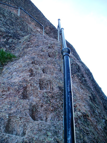
Something I meant to write about yesterday after my Pinnacles adventure. As I was climbing up those footholds cut in the rocks, it came to me that no one in the world knew where I was, and I had only seen maybe a half-dozen other hikers all day, and I definitely did NOT have the 10 essentials with me. Probably not the smartest thing. But I was careful and I survived.... to do a drive on backroads in the desert the next day, thinking much the same thing. 

Right now I'm just east of San Diego having lunch. Another 2.5 hours to Yuma, where hopefully I'll have plenty of time to do washing and a little shopping before driving another hour or so to meet up with my Sierra Club trip. Also hoping to find a bike shop...Ipad says there's one near my hotel....where I can leave my bike to be cleaned up and tuned a bit. It's pretty sad looking after driving those dusty desert roads yesterday, needs a tune-up anyway, and I'm hoping I can leave it at a bike shop so I don't have to leave it on the back of my car, which will be parked somewhere out in the desert for the 4 days we'll be canoeing.

Later: Yuma at last! In my shorts, having a beer. Dropped my bike off, the laundry's in the wash, heading to Supercuts, just down the road, when it's done.

What a drive! Sea level at San Diego, then over three 4000+ foot passes, then back to sea level in the desert. This has got to be one of the most scenic freeway drives I've ever taken. The mountains east of San Diego are strewn, covered, with amazing house-sized boulders. No trees, just boulders and desert, even at 4000 feet. Then down below, after miles of scrub-desert, there are miles of beautiful sand dunes (the Algodones dunes, I think). When I biked through near  here in 2005, those dunes were covered with beautiful purple flowers, but that was in March; no sign of anything but sand this time. And dune buggies.

It's been a great trip so far, but I'm happy to not be driving much for the next couple of weeks. Just to the meeting point with Sierra Club tomorrow, and then next weekend from here to Las Vegas to meet up with WomanTours for the bike trip through Death Valley.

Too tired to mess with uploading pictures tonight....


Thursday, February 2, 2012

Pinnacles

 Starbucks right next to my hotel this morning... now that's what I'm talkin' about!

I got to Paso Robles just after dark last night, very tired. Asked the nice woman at the hotel where to eat, and she gave me this map that showed Red Brick Pizza very close, she said even within walking distance. Having walked quite a bit already (see below) I thought I'd drive there anyway. Couldn't really tell whether the restaurant was to the right or left, so I started out right...1/2 mile, nothing. Turned around, went almost a mile, nothing (now I'm tired and hungry and it's dark, I'm swearing). Back to the hotel, dammit, I'll just go to the crappy Denny's clone attached to the hotel. Sustenance, anyway. As I'm leaving the restaurant I notice...right there, almost ATTACHED to the hotel, are about 6 eateries, including the one I'd been looking for, and Starbucks. Like I say, I was tired, and it was dark.

Anyway, that walk... 8 strenuous miles and 1600 feet of elevation gain in 5 hours at Pinnacles National Monument. Have you ever heard of this place? Neither had I. Well worth a visit. After a 15 mile winding and scenic drive through wineries and those beautiful dry California hills, big rocky..well...pinnacles. Rock spires, ramparts, crags, massive monoliths, sheer-walled canyons. This is part of an ancient volcano, lying right atop the San Andreas fault. Blue oak and gray pine, 2 new trees I learned today. Gray pine has perhaps the most impressive cones I've ever seen  and blue oak has these odd, long and narrow acorns.

Euchie enjoying the balcony of the nice B&B in Carmel

 About 3/4 of the way through this hike I came to the High Peaks area, with a sign saying "steep and narrow". Wow!


Steep and narrow!